Pages

Friday, 23 October 2015

Data Gathering and Preparation for Frac Sand Mining Suitability Project

Goals and Objectives:

The goal of this project was to be able to download data for Trempealeau County, Wisconsin to obtain various types of data to be able to spatially analyze the effect that frac sand mining has on the county's environment. The task was then to be able to display the raw data in a form in which a Python script could read and process the data to create map outputs of the county data for railroads, soils, land cover, cropland, and elevation. This county was chosen for the assignment because of its proximity to frac sand mining. In addition, frac sand mining is heavily affecting counties surrounding Eau Claire, and its presence in the news is a constant reminder of its conflicting benefits and detriments to people and the environment.


Methods

Data for this lab were extracted from various online sources (figure 1). 


Figure 1. Online sources used for Trempealeau County.
Some of the websites required a box to be drawn around the desired study area, whereas other websites allowed the user to specify the study area based on county. All of these .zip files were downloaded to a folder and unzipped into a 'working' folder to separate the 'zipped' and 'unzipped' files, which ultimately reduced the file size.  Below is the work flow from beginning up until the point of need to use Python scripter of the preliminary project (figure 2). 
Figure 2. Work flow from beginning until needing to work in Python scripter. After the redundant information was deleted, maps were made in ArcMap.

Once the data was downloaded into the geodatabase the data could then be brought in to Python, a programming language (see the 'Python' tab at the top of the blog page). This gave an easy way to convert all of the data obtained from the online sources . Using Python can alleviate many headaches when processing large amounts of data. In the case of the preliminary project, the rasters from the geodatabase needed to be projected to the local projection, NAD83 HARN WISCRS Trempealeau County Feet and then be clipped to the county and extracted to the geodatabase (figure 3).


Figure 3. The project and clip/extract steps were done in this project using Python. 
A collection of maps were then created from the extracted raster files. It was a simple process after the script was all said and done (figure 4).

Figure 4. Various topographic maps of Trempealeau County, Wisconsin. The maps will be used in later labs to create a suitability model for frac sand mining sites in the county.

Data Accuracy:

A vital, yet often overlooked piece of the data collection puzzle is being aware of the data accuracy.This entails the nitty gritty of metadata which is the description of the content of the data. Metadata should include the following:


Scale: The ratio or relationship between a distance or area on a map and the corresponding distance or area on the ground, commonly expressed as a fraction or ration.

Effective Resolution: The appropriate detail in which a map depicts the location and shape of geographic features. If the map is small scale, the resolution is bigger. Thus meaning that the pixels will be bigger as well. This eliminates the need for unnecessary storage of extra pixels (figure 5).

Minimum Mapping Unit: A value that represents the smallest depictable or plotable object. This directly correlates with the effective resolution of a map (figure 5).

Figure 5. Table for the appropriate resolution for a select set of map scales. Note, Raster Resolution and Effective Resolution are synonymous.

Lineage: It is the documentation of the source materials from which a specific set of geographic data was derived. This helps the user keep track of who has altered the database. If there were to be an error in the data, it could be traced back to see where the error occurred.

Temporal Accuracy:A measure of data quality with respect to the representation of time in geographic databases, or basically how updated a source's data is.

Attribute Accuracy: The precision of the attribute database linked to the map's features.The more accurate the attribute data, the better the data source is to use.

A table was created to depict the data accuracy of the data obtained online (figure 6).
Figure 6. Data accuracy table of Trempealeau County datasets obtain from various online sources.


Conclusions:

There are a few specific concepts to be aware of when using datasets from different sources. As reflected in the data accuracy table (figure 4), all aspects of data vary in how updated they are, the attribute accuracy, resolution etc. These aspects effect how well and accurately the data is when put together in a map, much like the one created in this preliminary lab. Industry standards have attempted to keep the level of attribute accuracy (see ASPRS for industry standards) at a high level to maintain data integrity, but there are still some organizations that fail to include that vital information in the Metadata. This makes it difficult to use a data source when one is unaware of its accuracy, which then discredits these organization's data.
Thursday, 22 October 2015

Sand Mining in Western Wisconsin Overview

What is sand frac mining and where is it in Wisconsin?

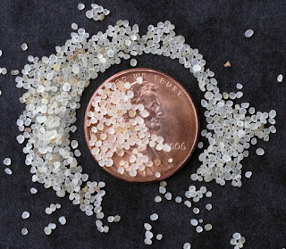
Frac sand is a silica sand (also known as quartz) whose characteristics include well sorted sand grains that are extremely hard and very well rounded (figure 1).

Figure 1. Individual grains of silica sand shown with a penny for scale. Not how well sorted and rounded the grains are.

The sand is found largely in Western Wisconsin, which is the primary area of the state which was unglaciated during the last Ice Age (figure 2).


Figure 2. The primary area in which frac sand mining occurs in the state of Wisconsin are located in sandstone geologic regions. The mines themselves are grouped primarily in western portion of the state (red squares show mine sites in 2013).


Frac sand mining has been in Wisconsin for the last 40 years, but has rapidly increased in production because of the booming petroleum industry (figure 3). Wisconsin alone holds more than 75% of the country's revenue for frac sand mining and there are 129 industrial sand facilities, 85 of which are still in operation. The sand is then used for hydraulic fracturing of natural gas all around the world.


Figure 3. There has been a boom in frac sand mining in Wisconsin, which has given the state an economic boost in the industry. The industry was worried that a drop in the price of oil would reduce demand for the mining, but that has yet to be seen in the state.


Hydraulic fracturing begins when a well is created that is hundreds to thousands of feet deep. In order to obtain gases and the like, water must be injected into the well at an extremely high pressure. This pressure causes fracturing to occur in the rock, thus allowing companies to extract the gas from the pockets that they hope to 'fracture' into (figure 4).


Figure 4. Diagram of how frac sand is used to extract gas. The sand, water and other chemicals are pumped below the groundwater at a very high pressure, which then opens weak points in the rock hundreds of feet below the surface. The newly created fractures access the pockets of gas, which can then be brought to the surface.

What's the problem with sand frac mining in Western Wisconsin?

Citizens of frac sand mining areas are concerned for their health and well being. One of the issues with this mining is the release of airborne particulate matter (figure 5). This matter in the form of silica dust finds its way into human lungs, which has been found to cause cancer and respiratory issues that lead to illness and even death.


Figure 5. An aerial view of the surface impact that frac sand mining has on the land. The particulates unearthed in the process of mining are exposed at mines like this one.


In Wisconsin there are very few regulations regarding air, water, and groundwater controls on mining of frac sand. The water use for sand mining ranges from 420,500 to 2 million gallons of water per day. This extreme water use is unsustainable for the current human population, in addition to the biological strain this places on the natural environment.

GIS Application for the Frac Sand Industry

GIS is a primary tool in identifying and solving issues such as frac sand mining in the area. We will use various data sets to answer questions regarding the components of Trempealeau county's make up including land use/land cover, cropland, railroads, and digital elevation models. In the semester, ArcGIS will be used to create a suitability and risk model for frac sand mining in western Wisconsin, and more specifically Trempealeau County. These databases will be obtained from governmental organizations including USGS, SSURGO, USDA, and the Trempealeau County geodatabase.


Works Cited: