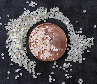
Frac sand is a silica sand (also known as quartz) whose characteristics include well sorted sand grains that are extremely hard and very well rounded (figure 1).
 |
| Figure 1. Individual grains of silica sand shown with a penny for scale. Not how well sorted and rounded the grains are. |
The sand is found largely in Western Wisconsin, which is the primary area of the state which was unglaciated during the last Ice Age (figure 2).
Frac sand mining has been in Wisconsin for the last 40 years, but has rapidly increased in production because of the booming petroleum industry (figure 3). Wisconsin alone holds more than 75% of the country's revenue for frac sand mining and there are 129 industrial sand facilities, 85 of which are still in operation. The sand is then used for hydraulic fracturing of natural gas all around the world.
Hydraulic fracturing begins when a well is created that is hundreds to thousands of feet deep. In order to obtain gases and the like, water must be injected into the well at an extremely high pressure. This pressure causes fracturing to occur in the rock, thus allowing companies to extract the gas from the pockets that they hope to 'fracture' into (figure 4).
What's the problem with sand frac mining in Western Wisconsin?
Citizens of frac sand mining areas are concerned for their health and well being. One of the issues with this mining is the release of airborne particulate matter (figure 5). This matter in the form of silica dust finds its way into human lungs, which has been found to cause cancer and respiratory issues that lead to illness and even death.
 |
| Figure 5. An aerial view of the surface impact that frac sand mining has on the land. The particulates unearthed in the process of mining are exposed at mines like this one. |
In Wisconsin there are very few regulations regarding air, water, and groundwater controls on mining of frac sand. The water use for sand mining ranges from 420,500 to 2 million gallons of water per day. This extreme water use is unsustainable for the current human population, in addition to the biological strain this places on the natural environment.
GIS Application for the Frac Sand Industry
GIS is a primary tool in identifying and solving issues such as frac sand mining in the area. We will use various data sets to answer questions regarding the components of Trempealeau county's make up including land use/land cover, cropland, railroads, and digital elevation models. In the semester, ArcGIS will be used to create a suitability and risk model for frac sand mining in western Wisconsin, and more specifically Trempealeau County. These databases will be obtained from governmental organizations including USGS, SSURGO, USDA, and the Trempealeau County geodatabase.
Works Cited:
- Frac Sand in Wisconsin. (2012). Retrieved October 22, 2015, from http://wcwrpc.org/frac-sand-factsheet.pdf
- Frac Sand Mining. (n.d.). Retrieved October 22, 2015, from http://conservationvoters.org/issues/frac-sand-mining/
- Hydraulic Fracturing Background Information. (n.d.). Retrieved October 22, 2015, from http://water.epa.gov/type/groundwater/uic/class2/hydraulicfracturing/wells_hydrowhat.cfm
- Ivey, M. (2015, January 11). DNR reports no slowing in Wisconsin frac sand mining despite oil slump. Retrieved October 22, 2015, from http://host.madison.com/ct/news/local/writers/mike_ivey/dnr-reports-no-slowing-in-wisconsin-frac-sand-mining-despite/article_99ed073f-6d8d-599d-9771-57688e1e76c9.html
- Wisconsin Department of Natural Resources. (n.d.). Retrieved October 22, 2015, from http://dnr.wi.gov/topic/Mines/Sand.html


No comments:
Post a Comment